Science
I am an ecologist and data scientist dedicated to understanding how nature works. I love finding patterns in the chaos, using geospatial and large-scale analyses to uncover insights that make a real difference for people and the environment. Ultimately, my goal is to help decision-makers turn data into meaningful action to protect and restore the planet.
Research
I am currently a remote sensing researcher at Agroscope, the Swiss Confederation’s center of excellence for agricultural research. Here, I generate annual crop type and grassland intensity maps for Switzerland from 1990 to the present, combining state-of-the-art deep learning with temperature-aware subsampling of Sentinel-2 and Landsat imagery. These maps are designed to be actionable and feed directly into the Swiss National Greenhouse Gas Inventory. As such, the maps have been rigorously validated and checked for temporal consitency.
Prior to this, I worked as a data scientist in the interdisciplinary Crowther Lab at ETH Zurich, where I facilitated and accelerated the research of the group. I built geospatial mapping pipelines, developed global forest patch delineation algorithms, and curated hundreds of analysis-ready datasets. The best part of my work was when someone came to me with an audacious idea, and together we were able to bring it to life.
My research covers topics such as:
- Mapping cropland types and grassland intensity classes using Landsat and Sentinel2,
- The effect of forest fragmentation and degradation on agricultural yield and ecosystem productivity,
- The influence of biodiversity on non-native tree invasion, and its effect on forest productivity,
- Remote sensing techniques for monitoring forest carbon accumulation and functional traits,
- The role of human activity in preserving healthy forests and ensuring access to safe drinking water,
- Quantifying the ‘debt’ of human land use on carbon storage and biodiversity.
My full publication record can be found on Google Scholar.
SEED Index
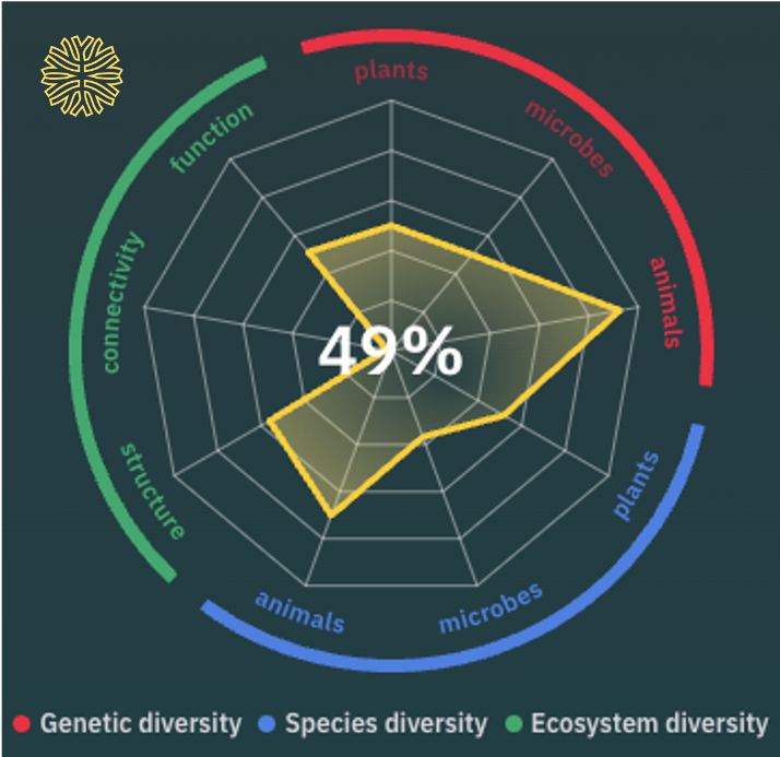
I am proud to have played a key role in the development of the SEED Biomcomplexity Index, the world’s most holistic measure of biodiversity. It quantifies the biological complexity of ecosystems worldwide by integrating existing ecological datasets, machine learning, and satellite information, tracking the state of genetic, species, and ecosystem diversity. Currently, the SEED Index beta version is under active development and being tested across several large-scale pilot projects.
I have contributed to the method development, prototyping, and provided support to SEED’s data scientists.